Friendship Groups &
Timor-Leste’s Administrative Divisions
Districts
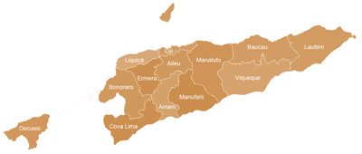
Timor-Leste has 13 administrative divisions or districts: Bobonaro, Liquiçá, Díli, Baucau, Manatuto and Lautém on the north coast; Cova‑Lima, Ainaro, Manufahi and Viqueque, on the south coast; Ermera and Aileu, the two landlocked districts; and Oecussi-Ambeno, the enclave in Indonesian territory. The borders of the 13 districts have been more or less the same since the last years of Portuguese administration. Each district comprises a capital city and various subdistricts whose number can vary between three and seven.
Subdistricts
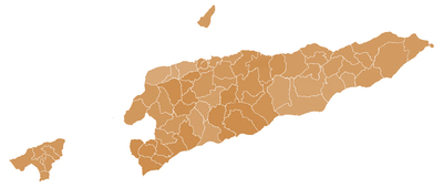
The 13 districts are subdivided into 67 sub-districts, with one designated as the capital, and administrative subdivisions – the so-called sukus (villages) – which vary between 2 and 18 per subdistrict.
Suku (Village) & Aldeias (Hamlet)
The smallest administrative division in Timor-Leste is the suku (village), which can comprise one or many aldeias (hamlets). The territory is divided into 498 villages, an average of seven per subdistrict.
Registered Friendship Groups by District
District of Aileu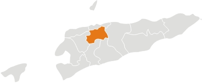
Aileu lies in the highlands to the south of Dili, the national capital. It has a population of 36,889 (2004) and an area of 729 km². The capital of the district is also named Aileu. Aileu district comprises the subdistricts of Aileu, Laulara, Liquidoe and Remexio.
Friends of Aileu
Friends of Aileu – Moreland City Council (VIC)
Friends of Aileu – Hume City Council (VIC)
Kangaroo Valley Remexio Partnership
Kangaroo Valley Remexio Partnership – Shoalhaven (NSW)
Ainaro District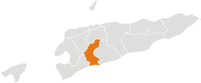
Ainaro is located in the southwest part of the country. It has a population of 53,629 inhabitants (census 2004) and an area of 797 km². The capital of the district is also named Ainaro. The district comprises the subdistricts of Ainaro, Hatudo, Hatu Builico and Maubisse. In addition to the official languages of the country (Tetun and Portuguese), the majority of the population speaks Mambai.
Ballarat Friends of Ainaro
Friends of Ainaro – City of Ballarat (VIC)
Bendigo-Maubisse Friendship Committee
Baucau District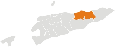
Baucau is located on the eastern part of the country, around 122 km of Dili. It is the second biggest city of the country with a population of 104,571 inhabitants (census 2004) and an area of 1,494 km². The capital of the district is also named Baucau. Baucau District comprises the subdistricts of Baguia, Baucau, Fatu Maca, Laga, Quelicai, Vemasse and Venilale (formerly known as Vila Viçosa). In addition to the official languages of the country (Tetun and Portuguese), the majority of the population speaks Macassai.
Friends of Baucau
Friends of Baucau – City of Darebin / City of Yarra (VIC)
Friends of Baguia
Friends of Baguia – City of Stonnington (VIC)
Friends of Venilale
Friends of Venilale – Mansfield Shire Council (VIC)
Monash Friends of Vemasse
Bobonaro District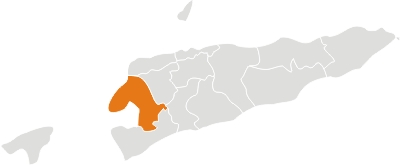
Bobonaro is located on the western part of the country, and borders Indonesia to the west. It has a population of 82,385 inhabitants (census 2004) and an area of 1,368 km². The capital of Bobonaro is Maliana, 149 km southwest of Dili, the national capital. The district includes the subdistricts of Atabae, Balibó, Bobonaro, Cailaco, Lolotoe and Maliana.
Friends of Lolotoe
Friends of Lolotoe (VIC)
Friends of Maliana
Friends of Maliana – Leichhardt Municipal Council (NSW)
Bosco Social Justice Group (NSW) (Affiliated with Friends of Maliana)
Cova Lima District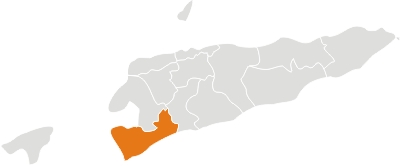
Cova Lima is located on the western part of the country and borders Indonesia to the west. It has a population of 55,941 inhabitants (census 2004) and an area of 1,226 km². The capital of Cova Lima is Suai which lies 136 km southwest of Dili, the national capital. Cova Lima district comprises the subdistricts of Fatululik, Fatumean, Fohorem, Zumulai, Maucatar, Suai and Tilomar.
Friends of Suai/Cova Lima
Díli District (capital)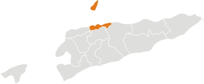
Díli lies on the north coast of the island. It has a population of 167,777 inhabitants (census 2004) and an area of 372 km². Its capital is the city of Dili which is also the national capital. Dili comprises the subdistricts of Atauro, Cristo-Rei, Dom Aleixo, Nain Feto, Metinaro and Vera Cruz.
Canberra Friends of Dili
Canberra Friends of Dili – ACT City Council (ACT)
Dili Sister City Community Group
Dili Sister City Community Group – Darwin City Council (NT)
Indigo Shire Atauro Island Friendship Group
Indigo-Atauro Friendship Group – Special Committee of Indigo Shire (VIC)
Ermera District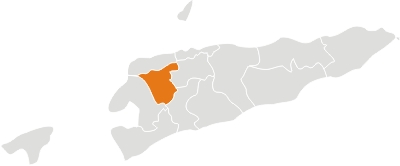
Ermera is located in the central part of the country. It has a population of 103,169 inhabitants (census 2004) and an area of 746 km². The capital of Ermera is Gleno, 58 km southwest of Dili, the national capital. Ermera comprises the subdistricts of Atsabe, Ermera, Hatólia, Letefuó and Railaco.
Friends of Ermera
Lautém District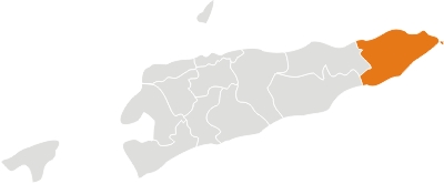
Lautém lies on the eastern end of Timor Island; it also includes Jaco island. It has a population of 57,453 inhabitants (census 2004) and an area of 1,702 km². The capital of Lautem is Lospalos, 248 km east of Dili, the national capital. Lautem comprises the subdistricts of Iliomar, Lautem Moro, Lospalos, Luro and Tutuala. In addition to the official languages of the country (Tetun and Portuguese), the population speaks Fataluku, a Papuan language spoken in the islands of New Guinea.
Mornington Peninsula Friends of Lospalos
Liquiçá District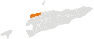
Liquiçá is located on the northern coast of the country, about 32 km of Dili. It has a population of 55,058 inhabitants (census 2004) and an area of 543 km². The capital of the district is also named Liquiça. The district comprises the subdistricts of Bazartete, Liquiça and Maubara. In addition to the official languages of the country (Tetun and Portuguese), the majority of the population speaks Tocodede.
Manatuto District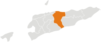
Manatuto is located in the central part of the country; it reaches both the south and north coasts of the island. It has a population of 38,580 inhabitants (census 2004) and an area of 1,706 km². The capital of the district is also named Manatuto. Manatuto comprises the subdistricts of Barique-Natarbora, Laclo, Laclubar, Laleia, Manatuto and Soibada. In addition to the official languages (Tetun and Portuguese), the majority of the population speaks Galóli, which is recognized as a “national language” by the Constitution.
Friends of Manatuto
Friends of Manatuto (VIC)
Pittwater Friends of Soibada
Friends of Soibada – Pittwatter Council (NSW)
Bega Valley Advocates for Timor-Leste
Manufahi District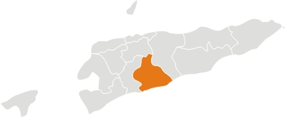
Manufahi is located on the south coast of the island. It has a population of 44,235 inhabitants (census 2004) and an area of 1,325 km². The capital of the district is Same. It now comprises the subdistricts of Alas, Fatuberliu, Same and Turiscai. In addition to the official languages of the country (Tetun and Portuguese), the majority of the population speaks Mambai.
Friends of Alas
Friends of Alas – Frenchs Forest Parish Social Justice Group / Warringah Council (NSW)
Macedon Ranges Friends of East Timor (Turiscai)
Macedon Ranges Friends of East Timor (Turiscai) – Macedon Ranges Shire Council (VIC)
Oecussi-Ambeno District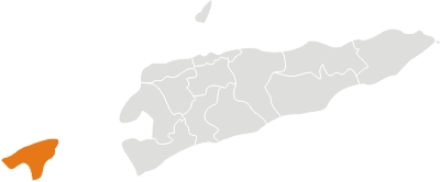
Oecussi-Ambeno is located on the north coast of the western part of Timor Island. It is separated from the rest of Timor-Leste by the Indonesian territory which surrounds the small enclave in all directions, except to the north, where it borders the Savu Sea. The territory has 58,521 inhabitants (census 2004) and an area of 815 km². The capital is the city of Pante Macassar. The district of Oecussi-Ambeno includes the subdistricts of Nitibe, Oesilo, Pante Macassar and Passabe. In addition to the official languages (Tetun and Portuguese), a great part of the population speaks Baikeno.
Friends of Oecussi
Viqueque District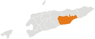
Viqueque is located on the south coast of the island. It has a population of 66,434 inhabitants (census 2004) and an area of 1,781 km². The capital of the district is also named Viqueque. The Viqueque district comprises the subdistricts of Lacluta, Ossu, Uatolari (formerly called Leça), Uato Carabau and Viqueque. In addition to the official languages of the country (Tetun and Portuguese), the majority of the population speaks Macassai.
Geelong Friends of Viqueque
Geelong Friends of Viqueque – City of Greater Geelong (VIC)
Geelong Viqueque Friendship Schools
Geelong Viqueque Friendship Schools – City of Greater Geelong (VIC)
Friends of Lacluta
Friends of Lacluta – Rural City of Wangaratta (VIC)
Willoughby Friends of Ossu
Sources
1. Information about the Districts (excluding the information about the Friendship groups) is abridged from the Administrative Division page on the Timor-Leste government site. Please visit that page for more details.
2. Information about the Friendship groups is based on registration details from those groups.
